Document REVISION: 12/28/2023
Please read the guide completely, call the local club officers (559)301-6356 or (559)285-7594 and share your learnings.
Here we go!
Dunlap now is to include all launches, both past and present (see below bullets for new names). As such this site guide will apply to all launches and landings with unique details provided for each. New pilots and longtime returning pilots should reach out to a local club member for a site intro. Much has changed in how we are flying this site.
• Dunlap - Main West Launch (SW – W)
• Dunlap - Main West Launch Ramp (SW – W)
• Dunlap - North Launch (W-NW)
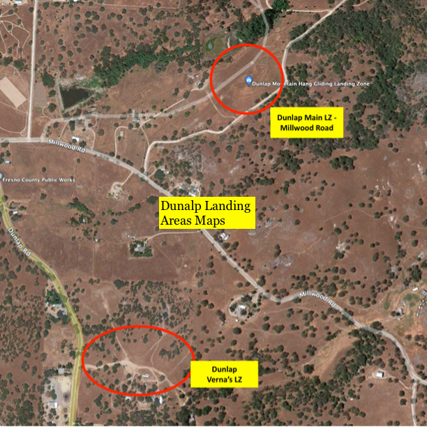
• Dunlap - Main LZ - Millwood Road LZ
• Dunlap - Verna’s LZ,
All Dunlap Launches are a P3 and H3 rated site. With that said, the distance on a dead glide from launch to landing for the Main West Launch & Ramp launch is 5:1 and 5.2:1 for the North Launch which requires the ability to thermal in a mountain setting. Consider the conditions of the day before you launch and take note of the pilot skills and the environmental factors of this site guide when making your decision.
Quick Wind Reference:
Optimal wind conditions for paragliders is at 5-8 mph with gusts to 12 mph; maximum gusts to 15. The latter conditions are typical for the lovely glass-off conditions we get here.
Optimal wind conditions for hang gliders at 10-12 mph; maximum winds are 17 mph with gusts to 20 mph.
Wind amounts for each launch remain the same, however wind directions are different for each. Note: Launching early means landing early before the day starts to ramp, or staying up all day until conditions mellow out at the end of the day…
***Wind speeds noted above***
Dunlap - Main West Launch (SW – W) – P3/H3 - 5:1 Glide Ratio
Dunlap - Main West Launch Ramp (SW – W) – P3/H3 - 5:1 Glide Ratio
Dunlap - North Launch (W-NW) – P3/H3 – 5.2:1 Glide Ratio (To Main LZ on Millwood)
Note: You must sign the online waiver, become a member of our club, be able to show validation that you are a current USHPA member, be properly rated, and prepared to launch and land at Dunlap. Annual club members will be given gate combinations to fly, while temporary members must be accompanied by a full member to gain access.
Site Management
The CCHPC manages this flying site. For your first flight please contact a club officer or local to help familiarize yourself with the necessary information to maintain good relationships with the landowners.
Commercial Schools/Events:
Schools/Events must register with the chapter prior to flying and show proof of their insurance declaration page listing land owners as additionally insured. Contact a Club officer for more details.
All Pilots must be members of the USHPA with rating of at least a H3 or P3. H2 and P2 pilots are acceptable if under supervision of an instructor (note requirement above) or an USHPA observer (friends or experienced pilots, while valuable, do not qualify as an "observer"). . These are required because it is a semi-arid mountain site, and like many others in California, can become quite strong, windy, and turbulent during midday. Pilots inexperienced in mountain flying should launch early or late, and land before or after it becomes too strong.
We are fully aware of the spectrum of abilities with H3 and P3 pilots and because of that we are mentioning this caution. Ultimately, you are the pilot in command and need to decide if you can safely navigate given the day’s conditions to the designated landing area.
Pilot Skill Sets should include, but are not limited too the following:
Environmental Factors for this semi-arid mountain site include:
Pilots should note these when deciding to fly or not to fly and making judgment decisions on distances necessary to safely make the LZ.
Dunlap Main LZ – Millwood Road LZ
CCHPC has permission to use this property for hang gliding and paragliding activities only. When using this land, please respect the privacy of the occupants of the homes on the land. No Drones or RC flying is allowed at the landing area.
The address is 40066 Milwood Rd. Dunlap, CA. 93667, GPS 36°44'9.11"N 119° 6'19.91"W.
Please see map for details on where to land and park. Please note that out-landing in the Dunlap or surrounding valleys is not permitted without prior approval from landowners.
There are places to park near the shed and Port-a-Potty, though make sure you stay out of the landing path. Again, please avoid parking near where there could be extended landings. Feel free to walk the landing area to gain perspective for your landing approach...
If you see any litter it becomes your property. Pick it up and properly dispose of it. We are guests on someone’s private property. Please be respectful.
There are special risks to be considered when landing here:
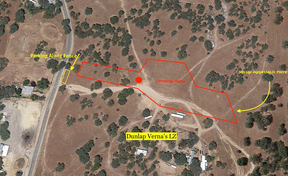
Dunlap Verna’s LZ
The address is 40320 Dunlap Road, Dunlap CA 93621, GPS 36°46'9.25"N 119° 6'7.34"W.
Please see map for details on where to land and park. Please note that out-landing in the Dunlap or surrounding valleys is not permitted without prior approval from land owners.
When entering the property, please open and shut the gate immediately after entering or exiting the property as there are cattle and horses that can escape. There are places to park immediately along and inside the fence to your left as you enter the gate. Please avoid parking near where there could be extended landings. Feel free to drive the landing area to gain perspective for your landing approach... If you see any litter, it becomes your property. Pick it up and properly dispose of it. We are guests on someone’s private property. Please be respectful.
Please do not attempt to spook the cattle or horses as you come into land. They will get out of the way and after you land, they will be curious.
The club asks that you pick up after yourself once you're done and to be diligent in opening and closing the gate.
There are special risks to be considered when landing here:
Dunlap West Main Launch / Dunlap West Main Ramp Launch
The launch is at GPS 36°45'54.14"N 119° 5'53.20"W. It is accessed via FS 13S97, off Hwy 180 Road. After you turn off the main Hwy, you will eventually make a left on FS 12519 toward Sequoia Highlands Camp. This road is paved at first, then turns to gravel, but is considered good quality.
Full Members can contact a club officer for the gate combination and temporary members must be accompanied by a full member to get the gate combination. The gate has a CCHPC Sign posted on it. Please open and close the gate immediately and re-lock locks only to other locks. Once inside the gate proceed and make your way up towards the Launch. Please review the map to locating the appropriate parking and setup areas.
We are guests and your actions impact everyone’s ability to launch at this site.
There are two launches. The Main West Launch (near the cabin), which is suited for both hang gliders and paragliders and is the preferred launch. The second is the Main West Launch Ramp launch, which is only for hang gliders. Watch the winds and wait for the right cycle.
Optimal wind conditions for paragliders is at 5-8 mph with gusts to 12 mph; maximum gusts to 15. The latter conditions are typical for the lovely glass-off conditions we get here.
Optimal wind conditions for hang gliders at 10-12 mph; maximum winds are 17 mph with gusts to 20 mph.
Pilots are urged to set up their equipment in the designated setup areas.
Flying conditions in front of launch are a mixture of dynamic and thermal lift, and pilots should know and follow traffic rules when there are other pilots in the air. If a pilot feels that the flying is too crowded, they should fly to an area clearer of traffic or fly out to the valley. Pilots flying near midday should watch how the wind speed and direction changes.
After you launch, you will want to fly immediately start looking for thermals to gain altitude. A house thermal exists on both ridges to the north and south. Have a local point this location out as it will be key to staying up. It is recommended not to get too low near launch. If you are getting low, move south and try to find lift as you move down the ridge toward the LZ (Low is considered 400-500 feet below Launch).
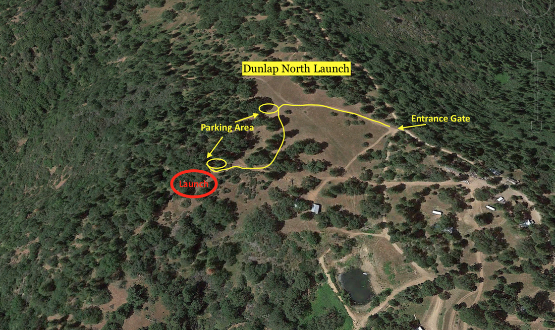
Dunlap North Launch
The launch is at GPS 37.76940N -119.1014299. It is accessed via FS 13S97, off Hwy 180 Road. After you turn off the main Hwy, you will eventually make a left on FS 12519 to get to Sequoia Highlands Camp. This road is paved at first, then turns to gravel, but is considered good quality.
Please pass the Main Launch and past the main Sequoia Highland Camp entrance and look for a gate on the left. Full Members can contact a club officer for the gate combination and temporary members must be accompanied by a full member to get the gate combination. The gate has a CCHPC Sign posted on it. Please open and close the gate immediately and re-lock locks only to other locks. Once inside the gate proceed west and then make your way up towards the top of Mt. Sampson. The road will pass an old rusted water tank, parking will be just past this. Do not attempt to drive down to the launch area. Park and walk your equipment and be sure to leave room for a few hang gliders to setup here.
We are guests and your actions impact everyone’s ability to launch at this site. The launch area is sloped, slightly off camber, and being developed. It is suitable for all hang glider and paraglider pilots with the appropriate ratings. You will see the obvious foot path down to the launch area. It is recommended that Hang Gliders setup above and walk their equipment down. Watch the winds and wait for the right cycle.
Optimal wind conditions for paragliders is at 5-8 mph with gusts to 12 mph; maximum gusts to 15. The latter conditions are typical for the lovely glass-off conditions we get here
Optimal wind conditions for hang gliders at 10-12 mph; maximum winds are 17 mph with gusts to 20 mph.
Pilots are urged to set up their equipment downhill from where their vehicles are parked, and walk to the takeoff area only when they are ready to launch.
Flying conditions in front of launch are a mixture of dynamic and thermal lift, and pilots should know and follow traffic rules when there are other pilots in the air. If a pilot feels that the flying is too crowded, they should fly to an area more clear of traffic or fly out to the valley. Pilots flying near midday should watch how the wind speed and direction changes.
After you launch, you will want to fly south and immediately start looking for thermals to gain altitude. A house thermal exists one ridge over and in front. Have a local point this location out as it will be key to staying up. It is recommended not to get too low near launch. If you are getting low, move south and try to find lift as you move down the ridge.
This is a new flying site, please share information and feedback with the club that you think pilots could benefit from knowing about. Together we will make this site better and better.
Flying Hazards
Pilots must fly over ridges protruding off the mountain to get to the landing area. It is imperative that they leave the ridge with sufficient altitude to do so. During approach to the landing field, pilots should monitor wind as they make circles, and avoid drifting too far into the landing area. Setup far back and plan to land well before the breakdown area.
When transitioning from launch to Delilah, pilots should do so well out front, as the back ridge forms a saddle with strong winds. Once at Delilah, pilots will see that the glide requirements to the LZ have increased significantly; pilots should commit to the LZ early, especially those with lower performance aircraft.
Cross Country Options
Like other sites in California, the best XC conditions can be found during unstable days in the spring/summer. There are known do not land areas like Bear Mountain Pizza, Please connect with local pilots on what the best routes are and where to avoid.
Incident Reporting
All incident reporting should be sent to club officers immediately for review in an effort to avoid incidents in the future. You can find contact info in the contacts page. They should then be reported to the national organization via this link: https://airs.ushpa.aero/
Please read the guide completely, call the local club officers (559)301-6356 or (559)285-7594 and share your learnings.
Here we go!
Dunlap now is to include all launches, both past and present (see below bullets for new names). As such this site guide will apply to all launches and landings with unique details provided for each. New pilots and longtime returning pilots should reach out to a local club member for a site intro. Much has changed in how we are flying this site.
• Dunlap - Main West Launch (SW – W)
• Dunlap - Main West Launch Ramp (SW – W)
• Dunlap - North Launch (W-NW)
• Dunlap - Main LZ - Millwood Road LZ
• Dunlap - Verna’s LZ,
All Dunlap Launches are a P3 and H3 rated site. With that said, the distance on a dead glide from launch to landing for the Main West Launch & Ramp launch is 5:1 and 5.2:1 for the North Launch which requires the ability to thermal in a mountain setting. Consider the conditions of the day before you launch and take note of the pilot skills and the environmental factors of this site guide when making your decision.
Quick Wind Reference:
Optimal wind conditions for paragliders is at 5-8 mph with gusts to 12 mph; maximum gusts to 15. The latter conditions are typical for the lovely glass-off conditions we get here.
Optimal wind conditions for hang gliders at 10-12 mph; maximum winds are 17 mph with gusts to 20 mph.
Wind amounts for each launch remain the same, however wind directions are different for each. Note: Launching early means landing early before the day starts to ramp, or staying up all day until conditions mellow out at the end of the day…
***Wind speeds noted above***
Dunlap - Main West Launch (SW – W) – P3/H3 - 5:1 Glide Ratio
Dunlap - Main West Launch Ramp (SW – W) – P3/H3 - 5:1 Glide Ratio
Dunlap - North Launch (W-NW) – P3/H3 – 5.2:1 Glide Ratio (To Main LZ on Millwood)
Note: You must sign the online waiver, become a member of our club, be able to show validation that you are a current USHPA member, be properly rated, and prepared to launch and land at Dunlap. Annual club members will be given gate combinations to fly, while temporary members must be accompanied by a full member to gain access.
Site Management
The CCHPC manages this flying site. For your first flight please contact a club officer or local to help familiarize yourself with the necessary information to maintain good relationships with the landowners.
Commercial Schools/Events:
Schools/Events must register with the chapter prior to flying and show proof of their insurance declaration page listing land owners as additionally insured. Contact a Club officer for more details.
All Pilots must be members of the USHPA with rating of at least a H3 or P3. H2 and P2 pilots are acceptable if under supervision of an instructor (note requirement above) or an USHPA observer (friends or experienced pilots, while valuable, do not qualify as an "observer"). . These are required because it is a semi-arid mountain site, and like many others in California, can become quite strong, windy, and turbulent during midday. Pilots inexperienced in mountain flying should launch early or late, and land before or after it becomes too strong.
We are fully aware of the spectrum of abilities with H3 and P3 pilots and because of that we are mentioning this caution. Ultimately, you are the pilot in command and need to decide if you can safely navigate given the day’s conditions to the designated landing area.
- All Pilots must use helmets and have reserve parachutes.
- All Flights must be in accordance with FAR Part 103.
- No dangerous maneuvers allowed
- No speed wings
- We do not have permission for towing operations
- Radios are strongly advised; common frequency is 147.405
- In addition to the above regulations, FAR part 103 and other USHPA regulations should supersede and be followed at all times.
Pilot Skill Sets should include, but are not limited too the following:
- Thermal flying, required to be able to reduce the glide necessary to make it to the LZ
- Turbulence flying, mid-day conditions can be quite rowdy
- Ridge Soaring, required to be able to reduce the glide necessary to make it to the LZ
- Foot Launch, specifically a good clean strong run
- Weather interpretation, the ability to know if conditions will allow you to make the Landing zone
Environmental Factors for this semi-arid mountain site include:
- Strong thermal activity mid-day
- Increasingly strong winds without notice
- Rough and sometimes extreme turbulence
- Changing wind directions from morning to afternoon to evening
Pilots should note these when deciding to fly or not to fly and making judgment decisions on distances necessary to safely make the LZ.
Dunlap Main LZ – Millwood Road LZ
CCHPC has permission to use this property for hang gliding and paragliding activities only. When using this land, please respect the privacy of the occupants of the homes on the land. No Drones or RC flying is allowed at the landing area.
The address is 40066 Milwood Rd. Dunlap, CA. 93667, GPS 36°44'9.11"N 119° 6'19.91"W.
Please see map for details on where to land and park. Please note that out-landing in the Dunlap or surrounding valleys is not permitted without prior approval from landowners.
There are places to park near the shed and Port-a-Potty, though make sure you stay out of the landing path. Again, please avoid parking near where there could be extended landings. Feel free to walk the landing area to gain perspective for your landing approach...
If you see any litter it becomes your property. Pick it up and properly dispose of it. We are guests on someone’s private property. Please be respectful.
There are special risks to be considered when landing here:
- The landing area can become quite turbulent during midday, and wind strength and direction can change quickly. While approaching please pay consistent attention to windsocks. Look for dust devils.
- The area available for landing is quite large. Do not take unnecessary risks to achieve a spot-landing in order to shorten the hike.
- Commit early to flying to the LZ; do not take chances hoping to arrive low. “I got too low” is not an emergency; it is poor piloting and puts the site at risk.
- Valley winds can become quite strong, making the trip to the LZ risky or impossible. Surrounding the LZ are dense trees, bushes, low power lines and occupied buildings. Beginning pilots with low-performance aircraft should take particular care. Mini-wings are not allowed at Dunlap North, as the glide slope is too shallow, regardless of pilot skills.
Dunlap Verna’s LZ
The address is 40320 Dunlap Road, Dunlap CA 93621, GPS 36°46'9.25"N 119° 6'7.34"W.
Please see map for details on where to land and park. Please note that out-landing in the Dunlap or surrounding valleys is not permitted without prior approval from land owners.
When entering the property, please open and shut the gate immediately after entering or exiting the property as there are cattle and horses that can escape. There are places to park immediately along and inside the fence to your left as you enter the gate. Please avoid parking near where there could be extended landings. Feel free to drive the landing area to gain perspective for your landing approach... If you see any litter, it becomes your property. Pick it up and properly dispose of it. We are guests on someone’s private property. Please be respectful.
Please do not attempt to spook the cattle or horses as you come into land. They will get out of the way and after you land, they will be curious.
The club asks that you pick up after yourself once you're done and to be diligent in opening and closing the gate.
There are special risks to be considered when landing here:
- The landing area can become quite turbulent during midday, and wind strength and direction can change quickly. While approaching please pay consistent attention to windsocks. Look for dust devils.
- The area available for landing is quite large. Do not take unnecessary risks to achieve a spot-landing in order to shorten the hike.
- Commit early to flying to the LZ; do not take chances hoping to arrive low. “I got too low” is not an emergency; it is poor piloting and puts the site at risk.
- Valley winds can become quite strong, making the trip to the LZ risky or impossible. Surrounding the LZ are dense trees, bushes, low power lines and occupied buildings. Beginning pilots with low-performance aircraft should take particular care. Mini-wings are not allowed at Dunlap North, as the glide slope is too shallow, regardless of pilot skills.
Dunlap West Main Launch / Dunlap West Main Ramp Launch
The launch is at GPS 36°45'54.14"N 119° 5'53.20"W. It is accessed via FS 13S97, off Hwy 180 Road. After you turn off the main Hwy, you will eventually make a left on FS 12519 toward Sequoia Highlands Camp. This road is paved at first, then turns to gravel, but is considered good quality.
Full Members can contact a club officer for the gate combination and temporary members must be accompanied by a full member to get the gate combination. The gate has a CCHPC Sign posted on it. Please open and close the gate immediately and re-lock locks only to other locks. Once inside the gate proceed and make your way up towards the Launch. Please review the map to locating the appropriate parking and setup areas.
We are guests and your actions impact everyone’s ability to launch at this site.
There are two launches. The Main West Launch (near the cabin), which is suited for both hang gliders and paragliders and is the preferred launch. The second is the Main West Launch Ramp launch, which is only for hang gliders. Watch the winds and wait for the right cycle.
Optimal wind conditions for paragliders is at 5-8 mph with gusts to 12 mph; maximum gusts to 15. The latter conditions are typical for the lovely glass-off conditions we get here.
Optimal wind conditions for hang gliders at 10-12 mph; maximum winds are 17 mph with gusts to 20 mph.
Pilots are urged to set up their equipment in the designated setup areas.
Flying conditions in front of launch are a mixture of dynamic and thermal lift, and pilots should know and follow traffic rules when there are other pilots in the air. If a pilot feels that the flying is too crowded, they should fly to an area clearer of traffic or fly out to the valley. Pilots flying near midday should watch how the wind speed and direction changes.
After you launch, you will want to fly immediately start looking for thermals to gain altitude. A house thermal exists on both ridges to the north and south. Have a local point this location out as it will be key to staying up. It is recommended not to get too low near launch. If you are getting low, move south and try to find lift as you move down the ridge toward the LZ (Low is considered 400-500 feet below Launch).
Dunlap North Launch
The launch is at GPS 37.76940N -119.1014299. It is accessed via FS 13S97, off Hwy 180 Road. After you turn off the main Hwy, you will eventually make a left on FS 12519 to get to Sequoia Highlands Camp. This road is paved at first, then turns to gravel, but is considered good quality.
Please pass the Main Launch and past the main Sequoia Highland Camp entrance and look for a gate on the left. Full Members can contact a club officer for the gate combination and temporary members must be accompanied by a full member to get the gate combination. The gate has a CCHPC Sign posted on it. Please open and close the gate immediately and re-lock locks only to other locks. Once inside the gate proceed west and then make your way up towards the top of Mt. Sampson. The road will pass an old rusted water tank, parking will be just past this. Do not attempt to drive down to the launch area. Park and walk your equipment and be sure to leave room for a few hang gliders to setup here.
We are guests and your actions impact everyone’s ability to launch at this site. The launch area is sloped, slightly off camber, and being developed. It is suitable for all hang glider and paraglider pilots with the appropriate ratings. You will see the obvious foot path down to the launch area. It is recommended that Hang Gliders setup above and walk their equipment down. Watch the winds and wait for the right cycle.
Optimal wind conditions for paragliders is at 5-8 mph with gusts to 12 mph; maximum gusts to 15. The latter conditions are typical for the lovely glass-off conditions we get here
Optimal wind conditions for hang gliders at 10-12 mph; maximum winds are 17 mph with gusts to 20 mph.
Pilots are urged to set up their equipment downhill from where their vehicles are parked, and walk to the takeoff area only when they are ready to launch.
Flying conditions in front of launch are a mixture of dynamic and thermal lift, and pilots should know and follow traffic rules when there are other pilots in the air. If a pilot feels that the flying is too crowded, they should fly to an area more clear of traffic or fly out to the valley. Pilots flying near midday should watch how the wind speed and direction changes.
After you launch, you will want to fly south and immediately start looking for thermals to gain altitude. A house thermal exists one ridge over and in front. Have a local point this location out as it will be key to staying up. It is recommended not to get too low near launch. If you are getting low, move south and try to find lift as you move down the ridge.
This is a new flying site, please share information and feedback with the club that you think pilots could benefit from knowing about. Together we will make this site better and better.
Flying Hazards
Pilots must fly over ridges protruding off the mountain to get to the landing area. It is imperative that they leave the ridge with sufficient altitude to do so. During approach to the landing field, pilots should monitor wind as they make circles, and avoid drifting too far into the landing area. Setup far back and plan to land well before the breakdown area.
When transitioning from launch to Delilah, pilots should do so well out front, as the back ridge forms a saddle with strong winds. Once at Delilah, pilots will see that the glide requirements to the LZ have increased significantly; pilots should commit to the LZ early, especially those with lower performance aircraft.
Cross Country Options
Like other sites in California, the best XC conditions can be found during unstable days in the spring/summer. There are known do not land areas like Bear Mountain Pizza, Please connect with local pilots on what the best routes are and where to avoid.
Incident Reporting
All incident reporting should be sent to club officers immediately for review in an effort to avoid incidents in the future. You can find contact info in the contacts page. They should then be reported to the national organization via this link: https://airs.ushpa.aero/