Document REVISION: Dec 28, 2023
Tollhouse is a P3 and H3 rated site.
Note: You must sign waiver, show validation that you are a current USHPA member and properly rated to launch and land at Tollhouse.
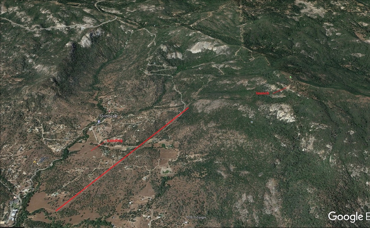
The glide from launch to the LZ is 3.5:1
Optimal wind conditions for paragliders is S to W at 3-8 mph with gusts to 12 mph; maximum winds are 12 mph with gusts to 15. The latter conditions are typical for the lovely glass-off conditions we get here.
Optimal wind conditions for hang gliders are S to W at 10-12 mph; maximum winds are 17 mph with gusts to 20 mph.
Tollhouse Site Procedures
The Tollhouse flying site is near the town of Tollhouse, California. The primary launch is near the top of Burroughs Mountain, which overlooks Tollhouse valley, and the landing zone is near the center of the valley. To the south is Burroughs valley, and is separated from Tollhouse by a low ridge; to the north is Big Sandy valley.
Site Management
Ron Jones is the local host. He will need to know your USHPA rating, and you must sign a waiver. Contact Ron at 559-313-0162 for a full run down on this beautiful site. There is a gate code that Ron will advise.
Commercial Schools/Events:
Schools/Events must register with the chapter prior to flying and show proof of their insurance declaration page listing land owners as additionally insured. Contact a Club officer for more details.
All Pilots must be members of the USHPA with rating of at least a H3 or P3. H2 and P2 pilots are acceptable if under supervision of an instructor (note requirement above) or an USHPA observer (friends or experienced pilots, while valuable, do not qualify as an "observer"). These are required because it is a semi-arid mountain site, and like many others in California, can become quite strong, windy, and turbulent during midday. Pilots inexperienced in mountain flying should launch early, and land before it becomes too strong.
Pilot Skill Sets should include, but are not limited too the following:
Environmental Factors for this semi-arid mountain site include:
Landing Area
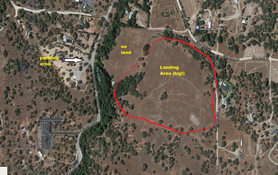
The required landing area is quite large, on a property currently owned by the Splan family. CCHPC has permission to use this property for hang gliding and paragliding activities. When using this land, please respect the privacy of the occupants of the home.
The address is 28645 Gibbs Ranch Road, GPS 37.010863 119.40189.
Please see map for details on where to land and how to access the landing field on foot. Please note that out-landing in the Tollhouse or Burroughs valleys is not permitted without prior approval from land owners.
Pilot vehicles must park across Tollhouse road from the property, in the lot for the local cemetery, unless otherwise instructed. If you see any litter it becomes your property. Pick it up and properly dispose of it.
There are special risks to be considered when landing here:
Launch
The launch is at GPS 37.0011490 119.37331 (N370.894 W119 22.3999). It is accessed via Burroughs Mountain road, off Tollhouse Road. Tollhouse road is paved and of good quality; Burroughs Mountain road is dirt, steep in areas, and requires aggressive 4WD.
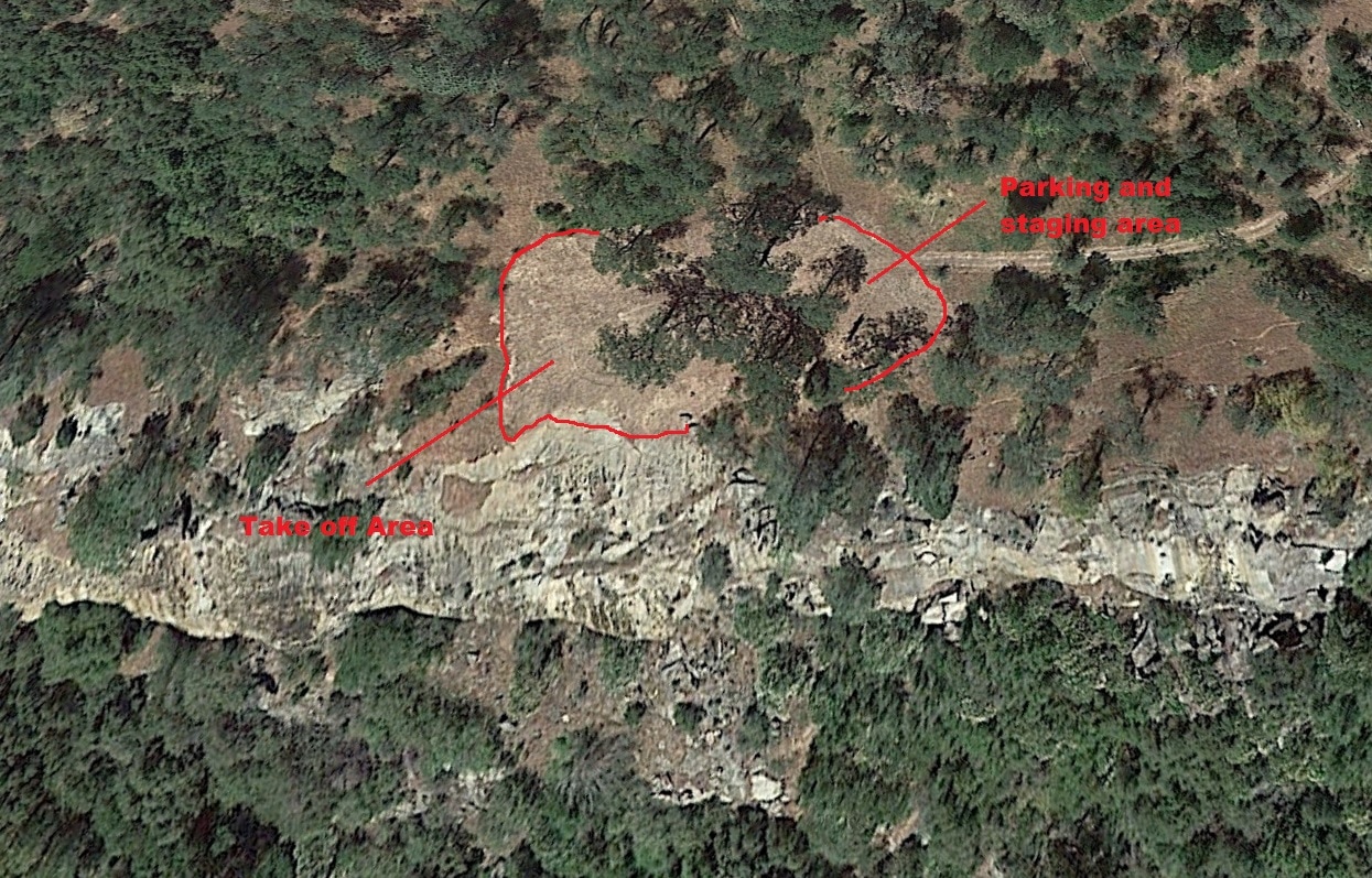
The launch area is large, with a gentle slope and a steep granite drop-off. It is suitable for all hang glider and paraglider pilots with the allowed ratings. There is no signage.
Optimal wind conditions for paragliders is S to W at 3-8 mph with gusts to 12 mph; maximum winds are 12 mph with gusts to 15. The latter conditions are typical for the lovely glass-off conditions we get here.
Optimal wind conditions for hang gliders are S to W at 10-12 mph; maximum winds are 17 mph with gusts to 20 mph.
Pilots are urged to set up their equipment on the side near vehicle parking, and walk to the takeoff area only when they are ready to launch. Spectators have the best view near the cliff, but should not be where they could interfere with safe launches.
Flying conditions in front of launch are a mixture of dynamic and thermal lift, and pilots should know and follow traffic rules when there are other pilots in the air. If a pilot feels that the flying is too crowded, they should fly to an area more clear of traffic (such as Squaw’s) or fly out to the valley. Pilots flying near midday should watch how the wind speed and direction change.
In the recent past there have been two accidents resulting in injury. In both cases a paraglider pilot lost control of their wing during launch and was dragged over obstacles. Pilots should be aware that the wind direction overhead is often different than that on the ground, and should abort early if they cannot maintain control of their glider.
Flying Hazards
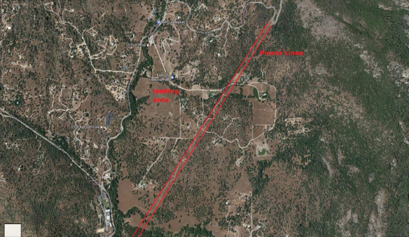
Pilots must fly over a system of high tension power lines to get to the landing area. It is imperative that they leave the ridge with sufficient altitude to do so. During approach to the landing field, pilots should monitor wind as they make circles, and avoid drifting into the power lines.
When transitioning from launch to Squaw’s, pilots should do so well out front, as the back ridge forms a saddle with strong venturi winds. Once at Squaw’s, pilots will see that the glide requirements to the LZ have increased; pilots should commit to the LZ early, especially those with lower performance aircraft.
In the recent past there have been multiple incidents involving pilots scratching close to the terrain in turbulent and/or leeside conditions, resulting in tree landings or use of their reserve parachute. Pilots should use extreme caution when flying close to terrain and identify and avoid leeside areas. Pilots must not allow the excitement of a racing environment cloud their judgment and their assessment of flying risks.
All pilots should consult with Ron, Tom, or regular flying pilots of the site to identify rotor areas/zones, lee side areas, changing conditions.
All pilots should maintain altitude clearances when landing out and avoid putting yourself in a difficult/dangerous position to safely make the desired landing location.
Mixed use issues
Only people with permission, including pilots, are allowed in the landing area. Vehicles who park in the cemetery lot should not impede other visitor’s access.
Tollhouse Rock is a favorite climbing area for local enthusiasts. Please take care not to block the road or access for the climbers.
Cross Country Options
Like other sites in California, the best XC conditions can be found during unstable days in the spring. Flights north to Eastman Lake and south to the town of Lindsay have been achieved.
Paraglider pilots typically head north to Squaws, then to Big Sandy Bluff, and to Black Mountain; from there they either go further north to Prather or southward via Humphrey Station. Hang glider pilots often go directly south via Burroughs Valley. Pilots should always be aware of landing options and approaches, as well as hidden obstacles like fences and power lines. If you have an awkward encounter with a land owner, please communicate this to Ron Jones so we can note the property as a no-land area. Always cross fences underneath, or at gates on the supported side.
Incident Reporting
All incident reporting should be sent to club officers immediately for review in an effort to avoid incidents in the future. You can find contact info in the contacts page. They should then be reported to the national organization via this link: https://airs.ushpa.aero/
Incidents and accidents should be reported to the national organization via this link: https://airs.ushpa.aero/
In addition report all accidents and close calls to the chapter via phone or email. [email protected]
The Tollhouse flying site is near the town of Tollhouse, California. The primary launch is near the top of Burroughs Mountain, which overlooks Tollhouse valley, and the landing zone is near the center of the valley. To the south is Burroughs valley, and is separated from Tollhouse by a low ridge; to the north is Big Sandy valley.
Site Management
Ron Jones is the local host. He will need to know your USHPA rating, and you must sign a waiver. Contact Ron at 559-313-0162 for a full run down on this beautiful site. There is a gate code that Ron will advise.
Commercial Schools/Events:
Schools/Events must register with the chapter prior to flying and show proof of their insurance declaration page listing land owners as additionally insured. Contact a Club officer for more details.
All Pilots must be members of the USHPA with rating of at least a H3 or P3. H2 and P2 pilots are acceptable if under supervision of an instructor (note requirement above) or an USHPA observer (friends or experienced pilots, while valuable, do not qualify as an "observer"). These are required because it is a semi-arid mountain site, and like many others in California, can become quite strong, windy, and turbulent during midday. Pilots inexperienced in mountain flying should launch early, and land before it becomes too strong.
- All Pilots must use helmets and have reserve parachutes.
- All Flights must be in accordance with FAR Part 103.
- No dangerous maneuvers allowed
- No speed wings, see below
- We do not have permission for towing operations
- Radios are strongly advised; common frequency is 147.405
- Satellite tracking devices (e.g. Spot, InReach) are encouraged for XC
- In addition to the above regulations; FAR part 103 and other USHPA regulations should supersede and be followed at all times.
- No drugs, alcohol or tobacco allowed at the LZ per the property owners request
- No minors (under 18) will be allow to use the Tollhouse site
Pilot Skill Sets should include, but are not limited too the following:
- Cliff Launch and Foot Launch
- Thermal flying
- Turbulence flying, at times in the summer the air can be very rowdy
- Ridge Soaring
- Weather interpretation, the ability to know if conditions will allow you to make the LZ
Environmental Factors for this semi-arid mountain site include:
- Strong thermal activity mid-day
- Increasingly strong winds without notice
- Rough and sometimes extreme turbulence
- Changing wind directions from morning to afternoon to evening
Landing Area
The required landing area is quite large, on a property currently owned by the Splan family. CCHPC has permission to use this property for hang gliding and paragliding activities. When using this land, please respect the privacy of the occupants of the home.
The address is 28645 Gibbs Ranch Road, GPS 37.010863 119.40189.
Please see map for details on where to land and how to access the landing field on foot. Please note that out-landing in the Tollhouse or Burroughs valleys is not permitted without prior approval from land owners.
Pilot vehicles must park across Tollhouse road from the property, in the lot for the local cemetery, unless otherwise instructed. If you see any litter it becomes your property. Pick it up and properly dispose of it.
There are special risks to be considered when landing here:
- The landing area can become quite turbulent during midday, and wind strength and direction can change quickly. While approaching please pay consistent attention to windsocks. Look for dust devils.
- The area available for landing is quite large. Do not take unnecessary risks to achieve a spot-landing in order to shorten the hike.
- Commit early to flying to the LZ; do not take chances hoping to arrive low. “I got too low” is not an emergency; it is poor piloting and puts the site at risk.
- Valley winds can become quite strong, making the trip to the LZ risky or impossible. Surrounding the LZ are dense trees, bushes, low power lines and occupied buildings. Beginning pilots with low-performance aircraft should take particular care. Mini-wings are not allowed at Tollhouse, as the glide slope is too shallow, regardless of pilot skills.
Launch
The launch is at GPS 37.0011490 119.37331 (N370.894 W119 22.3999). It is accessed via Burroughs Mountain road, off Tollhouse Road. Tollhouse road is paved and of good quality; Burroughs Mountain road is dirt, steep in areas, and requires aggressive 4WD.
The launch area is large, with a gentle slope and a steep granite drop-off. It is suitable for all hang glider and paraglider pilots with the allowed ratings. There is no signage.
Optimal wind conditions for paragliders is S to W at 3-8 mph with gusts to 12 mph; maximum winds are 12 mph with gusts to 15. The latter conditions are typical for the lovely glass-off conditions we get here.
Optimal wind conditions for hang gliders are S to W at 10-12 mph; maximum winds are 17 mph with gusts to 20 mph.
Pilots are urged to set up their equipment on the side near vehicle parking, and walk to the takeoff area only when they are ready to launch. Spectators have the best view near the cliff, but should not be where they could interfere with safe launches.
Flying conditions in front of launch are a mixture of dynamic and thermal lift, and pilots should know and follow traffic rules when there are other pilots in the air. If a pilot feels that the flying is too crowded, they should fly to an area more clear of traffic (such as Squaw’s) or fly out to the valley. Pilots flying near midday should watch how the wind speed and direction change.
In the recent past there have been two accidents resulting in injury. In both cases a paraglider pilot lost control of their wing during launch and was dragged over obstacles. Pilots should be aware that the wind direction overhead is often different than that on the ground, and should abort early if they cannot maintain control of their glider.
Flying Hazards
Pilots must fly over a system of high tension power lines to get to the landing area. It is imperative that they leave the ridge with sufficient altitude to do so. During approach to the landing field, pilots should monitor wind as they make circles, and avoid drifting into the power lines.
When transitioning from launch to Squaw’s, pilots should do so well out front, as the back ridge forms a saddle with strong venturi winds. Once at Squaw’s, pilots will see that the glide requirements to the LZ have increased; pilots should commit to the LZ early, especially those with lower performance aircraft.
In the recent past there have been multiple incidents involving pilots scratching close to the terrain in turbulent and/or leeside conditions, resulting in tree landings or use of their reserve parachute. Pilots should use extreme caution when flying close to terrain and identify and avoid leeside areas. Pilots must not allow the excitement of a racing environment cloud their judgment and their assessment of flying risks.
All pilots should consult with Ron, Tom, or regular flying pilots of the site to identify rotor areas/zones, lee side areas, changing conditions.
All pilots should maintain altitude clearances when landing out and avoid putting yourself in a difficult/dangerous position to safely make the desired landing location.
Mixed use issues
Only people with permission, including pilots, are allowed in the landing area. Vehicles who park in the cemetery lot should not impede other visitor’s access.
Tollhouse Rock is a favorite climbing area for local enthusiasts. Please take care not to block the road or access for the climbers.
Cross Country Options
Like other sites in California, the best XC conditions can be found during unstable days in the spring. Flights north to Eastman Lake and south to the town of Lindsay have been achieved.
Paraglider pilots typically head north to Squaws, then to Big Sandy Bluff, and to Black Mountain; from there they either go further north to Prather or southward via Humphrey Station. Hang glider pilots often go directly south via Burroughs Valley. Pilots should always be aware of landing options and approaches, as well as hidden obstacles like fences and power lines. If you have an awkward encounter with a land owner, please communicate this to Ron Jones so we can note the property as a no-land area. Always cross fences underneath, or at gates on the supported side.
Incident Reporting
All incident reporting should be sent to club officers immediately for review in an effort to avoid incidents in the future. You can find contact info in the contacts page. They should then be reported to the national organization via this link: https://airs.ushpa.aero/
Incidents and accidents should be reported to the national organization via this link: https://airs.ushpa.aero/
In addition report all accidents and close calls to the chapter via phone or email. [email protected]
The launch is at GPS coordinates 37.0011490 119.37331 (N370.894 W119 22.3999)
Red Line In The Map Below Shows High Line Wires Near The Landing Zone, be sure to make every safe effort to make the LZ
Landing Zone GPS coordinates: 37.010863 119.40189
If you see any litter it becomes your property. Pick it up and properly dispose of it.
The gate must be locked at all times.
The gate must be locked at all times.


